Editor's Notebook
July 2, 2020
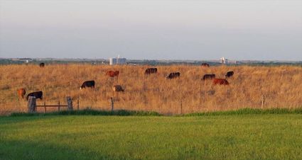
The arrow points to the same structure in both pictures. Above, the normally crisp, clean air lets one see the structures Superior - especially the elevators: Holcim, Aurora Cooperative and Agrex. Sunday, dust from the Sahara Desert in Africa blanketed the area, creating diminishing visibility. The pictures were taken within 50 yards of one another from the hill south of Superior known as Blauvelt's Hill.
A few days ago a friend living out-of-state said "I love sand but I prefer it on the beach."
I didn't understand the comment when it was made but I do now for it referred to the Saharan dust plume that reached the United States in late June.
We got to experience the edge of that plume Sunday. While it apparently was much worse on the gulf coast, I certainly didn't enjoy the sand storm it brought to our area on Sunday.
I don't want a repeat, but weather forecasters indicate another plume of Saharan dust is expected to reach the southern parts of the United States this week. Lower concentrations of the dust are forecast to spread into the plains states.
The mass of extremely dry and dust air known as the Saharan Air Layer forms over the Sahara Desert and moved across the North Atlantic every three to five days from late spring to early fall, peaking in late June to mid-August, according to the National Oceanic and Atmospheric Administration.
Sunday's dust cloud was described by reporters as a "Godzilla." It extended much farther into the United States than such clouds normally do.
While the dust reduced visibility and caused some people to have respiratory problems, it was not without benefits. One of those benefits is that such clouds tend to prevent tropical storms and hurricanes from developing. Tropical storms need a lot of moist air and relatively calm upper level winds to form. The lack of moisture and increased winds are not conducive for tropical storm development. Earlier indications were that the United States would see more than the normal amount of hurricanes this year. So hopefully the dust will suppress hurricane development.
It is thought the dust will make for more colorful sunsets and sunrises.
Chris Dolce, a meterologist, told the Associated Press, "This outbreak of dust, along with unfavorable upper-level winds, will likely put a lid on any significant tropical development in the near term."
After touring the southern United States for more than a week the intrepid plume of African dust that hovered over this area Sunday, has now withdrawn from the United States. In addition to poor air quality and reduced visibility, it was blamed for record heat in South Florida. Experts said the dust was one of the most prolific in the modern area. Some think it may have been a record. It will likely be studied for years to come.
The dust particles were surprisingly uniform indicating they came from a rather localized area of Africa.
Additional waves of dust are expected across the Atlantic in early July. Such waves of dust and sand form every three to five days from late spring into early fall according to the National Oceanic and Atmospheric Administration.
Most years the dust clouds do little more than amplify sunsets and coat the Caribbean island with a thin layer of dust and choke the air with a dry haze that may cut visibility by more than half. But this year's giant cloud was more than 4,000 miles long and two miles thick.
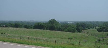
Sunday, curious about the haze we were seeing here in Superior, Rita and I went to the Kansas Hills where I was raised so we could look over the Superior and the Republican River Valley. As a youngster, I passed many an hour perched with binoculars on the windmill tower studying the spreading valley. This week, I didn't need the binoculars for Superior disappeared in the haze.
Searching for way to document the haze, we decided to take a picture in the same general area where we had taken one earlier in the spring. When we took the first picture our point of interest was the cattle grazing. But look beyond the cattle and the picture shows the Superior elevators and other valley features. In this week's picture those elevators are shrouded in dust.


Reader Comments(0)