An overview of the physiographic features of Jewell County
Physiographic features of Jewell County
January 6, 2022
Physiographic features of Jewell County
By Kerma Crouse
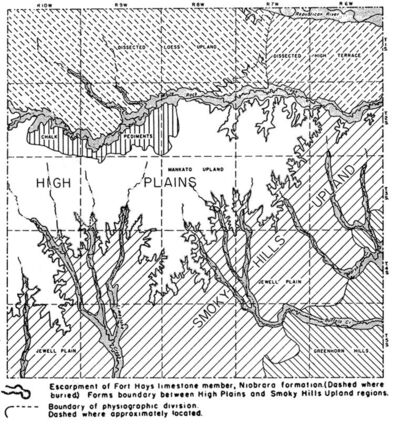
In a relatively obscure 1955 publication, "Geology and Ground-Water Resources of Jewell County, Kansas," authors V. C. Fishel and Alvin R. Leonard included a map of the physiographical features of Jewell County. These features include the Greenhorn Hills, the Jewell Plain, the Mankato Upland as well an area of Chalk Pediments.
The Greenhorn Hills are in the southeast corner of the county – Allen Township. With the exception of a few scant acres in the northwest corner of the township, the Greenhorn Hills occupy the entire township. They roll across into the eastern third of Prairie Township, the eastern half of Vicksburg Township and the southeastern corner of Grant Township. These rough rolling hills host picturesque pastures and grazing cattle.
When one looks at a physiographic map of the State of Kansas, Jewell County is entirely in the Smoky Hills. So, it might seem logical the largest physiographic area in Jewell County is the Smoky Hills Upland. This area is in and around Little Oak Creek, Limestone Creek, Buffalo Creek and Marsh Creek.
The Smoky Hills Upland takes up the remainder of Grant, Prairie and Vicksburg townships plus it claims the entirety of Brownscreek, Athens and Buffalo townships. This upland dominates the southern half of Sinclair Township and sneaks into the southeastern corner of Highland Township.
The upland is found in the eastern third and southwestern corner of Washington Township and all but the northwestern corner of Calvin Township. Nearly all of Ionia and Erving townships are part of the Smoky Hills Upland as are the areas close to the West Branch of the Limestone and Little Oak creeks in Odessa Township. Likewise, the areas close to the three branches of Buffalo Creek in Center Township are part of the Smoky Hills Upland.
There are two areas marked "Jewell Plain" in the Smoky Hills Upland. One is east of Jewell and the other between Little Oak Creek and West Limestone Creek in Erving and Athens townships.
A small area from around White Mound to east of Burr Oak lying south of White Rock Creek is referred to as the Chalk Pediments. This area has above-ground rock formations and is nestled near the creek.
The rest of the area north of the Smoky Hills Upland and south of White Rock Creek is referred to as the High Plains. This includes the areas of Erving, Odessa, Ionia, Calvin and Highland townships not part of the Smoky Hill Upland.
Also included are nearly all of Esbon, Limestone, Center townships and the northwestern half of Washington Township. The center of Jewell County, Center Township is also the location of the Mankato Upland.
The areas south of White Rock Creek in White Mound, Burr Oak, Holmwood and Harrison townships, those areas which are not in the Chalk Pediments, are part of the High Plains. The High Plains also slides into the western edge of Sinclair Township.
The Dissected Loess Upland lies in northwestern Jewell County. This is an area of rough pastures with gullies and crevices (dissected) hills with a windblown sediment soil called loess. The entire area is higher (upland) than the area around White Rock Creek.
This upland area has the highest point in Jewell County. Simply called Jewell County High Point, it is in the northwestern most corner of Highland Township.
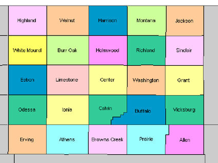
Jewell County has 25 townships. This map is designed to assist you with knowing where the county's physiographic features are located.
The Dissected Loess Upland consists of all of Highland, Walnut, Harrison and the western half of Montana townships plus everything north of White Rock Creek in White Mound, Burr Oak, Holmwood, and the western side of Richland townships.
The final physiographic area in Jewell County is the Dissected High Terrace in the northeastern portion of the county. The hills in the area also have gullies and crevices but are not known for the loess of the northwestern portion of the county. This area is between the Republican River and White Rock Creek in Montana, Jackson, Richland and Sinclair townships.
So, in which physiographic area do you live? The Greenhorn Hills or Smoky Hills Upland? What about the Jewell Plain or the Mankato Upland? Maybe the High Plains or Chalk Pediments? Finally is it the Dissected Loess Upland or the Dissected High Terrace?


Reader Comments(0)