Weather Service tracks tornado over Ruskin
June 16, 2022
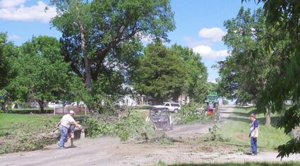
Volunteers hauled tree limbs to the Ruskin burn pile northeast of town last Wednesday afternoon after a tornado trimmed the townʼs trees Tuesday evening. Above, a parade of tree limbs are moved to the burn pit with a John Deere tractor and grapple fork leading the procession followed by an older model tractor and trailer. A four-wheeler works in the foreground as members of the Drohman family drag limbs into the street for the next trip to the burn pile. No major structural damage was reported. However, there was at least one person injured in the cleanup work. People working in the area near where this picture was taken include Dustan, Nikki and Jase Drohman, Brian Paul, Kevin and JC Hintz, Doyle Lipker, Reed Hofts and Trent Sorensen.
We said in last week's paper that the week's real weather story would be written after the paper was printed. Unfortunately, that was true.
Tuesday and Saturday both brought some rough weather.
Saturday afternoon residents of this area could see majestic thunderheads in the deep blue eastern sky. While the constantly changing clouds were a joy to watch, we knew they meant bad news for someone.
It wasn't long before the news report began rolling in.
Hail as large as five inches in diameter was reported in the Beatrice area. High wind damaged trees at Wymore. As the storm tracked south, a tornado was reported at Marysville about 6:30 then at Manhattan. Communities like Blue Rapids and Waterville were left without electricity.
Nuckolls County didn't escape the storms.
Tuesday a storm spawned a tornado at Ruskin. With the peak wind speed estimated at 85 miles per hour it was rated an EF0 by the National Weather Service. The tornado moving from north to the southeast travelled 9.917 miles and had a maximum width of 25 yards.
It started at 9:42 p.m. last Tuesday
one mile northwest of Ruskin crossed over the town and ended at 9:51 three miles north of Byron.
Most the damage in Ruskin was confined to trees. At the Mussman farm it destroyed a shed and two empty grain binds. Two other, larger bins were damaged.
As the tornado traveled rapidly southeast, the National Weather Service said it may have upset a dozen center pivot irrigation systems, damaged at least two more grain bins, peeled tin and shingles from the rooftops of at least two buildings and damaged trees.
After Saturday night's storms, WIBW Radio reported one Marysville resident said, "The wind just took off like crazy, it was nuts."
The tornado struck Marysville, as Allison and Sam Lubbers were wrapping up their wedding ceremony and taking photos. They were at a wedding venue just a few hundred yards from a lumber shop that was partially destroyed.
A picture of a crushed sheriff's department cruiser has been circulated widely. The car appears to have been in use when crushed by bricks and other debris from a nearby building.
And as this week's paper is being put together on Tuesday evening, the National Weather Service has been expanding the severe weather watch area to include more of our coverage area. If storms develop, they may deliver locally heavy rainfall, wind gusts exceeding 60 miles per hour and hail near the size of golf balls.


Reader Comments(0)