
Winter storms keep rolling in
February 23, 2023
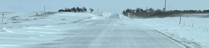
The snow storm Thursday, closed schools, slowed area business districts, and nearly stopped traffic for a few hours. Friday morning, traffic resumed, but roads were snow packed and treacherous as snow continued to blow across the road ways. Pictured above is a stretch of Highway 136 between Superior and Guide Rock Friday morning. By the weekend hardtop area roads were in excellent condition.
It appears the National Weather Service has prepared a forecast for last week and with only slight adjustment has issued it again for this week. The pattern calls for above normal temperatures followed by snow, high wind and cold.
As this paper went to press last week the forecast indicated a storm would arrive in this area Wednesday and continue into Thursday. The heaviest snow was forecast to be along the Kansas-Nebraska stateline and that was pretty much true. Wednesday was mostly dry and many folks went to bed that night thinking the weather forecasters were wrong. But in the predawn hours on Thursday, buckets of snow were pouring down along the stateline. Little snow was received in Beloit or Grand Island but the Weather Service reported Superior was in a band where reports of 6 inches were common.
The early snow was dry but the late Thursday morning snow contained more moisture and help to tack down the lighter fluffy snow.
Superior schools were closed on Thursday and the City of Superior had all snow removal equipment at work. A retired street department foreman, Dennis Gebers, was called back to help. Thursday he was observed cruising Superior plowing snow with the motor grader purchased after his retirement. Friday he was driving a dump truck hauling away the snow.
Bright sun appeared Thursday afternoon and by sunset dry streets and walks were showing up.
Above normal temperatures late in the week wiped away most traces of snow.
As this issue went to press Tuesday night, another winter storm was approaching. There were chances for snow Wednesday afternoon through early Thursday morning. Models were focusing the heaviest snow across northern Nebraska, the Dakotas and on into the Great Lakes region. A trace or less was in the forecast for Superior. It was also not out of the question that some of this precipitation might fall as a wintry mix of snow, sleet and freezing rain!

Accompanying the snow there were chances for northerly winds and gusts near 45 MPH especially Wednesday evening into Thursday morning.
Temperatures were expected to fall during the day on Wednesday, and dangerously cold wind chills of -20 to -30 were possible Wednesday night into this morning (Thursday.) Thursday night into Friday night will also have bitterly cold wind chills of -10 to -20, not quite as cold thanks to lighter winds.
The storm is coming in the heels of several days of above normal temperatures. Sunday was like a spring day with people outside sitting on their porches and the youngsters playing without jackets.
Reader Comments(0)