
Weather makes life interesting here
September 10, 2020
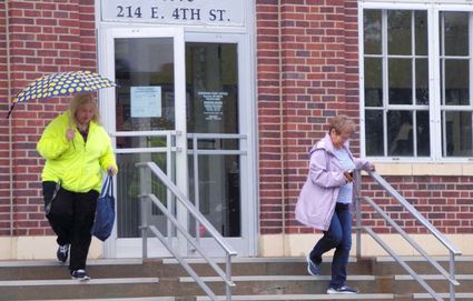
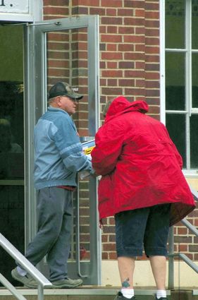
As these pictures show weather on the plains can change quickly. Within the week the National Weather Service expected both new high and low temperature records would be set for this area. The top photos show patrons going to the Superior Post Office on Tuesday morning weather wearing their winter coats. The lower photo shows swimmers were out in fore at the Lovewell Reservoir during the weekend.
When it comes to weather, area residents certainly have something to talk about though our extremes are not as great as they have been in Denver. After having weekend temperatures top the 100 degree mark earlier in the weekend, Denver residents on Monday were under a winter storm watch and preparing for snow. By midday Monday the temperature had reached 93 degrees before nose diving. By 11 p.m. it was 47 degrees. By 8 a.m. Tuesday it was down to 33 degrees.
Denver temperature records have been kept since 1872. That year on Jan. 25 the temperature dropped 66 degrees, a record that has yet to be broken. The temperature dropped from 46 degrees to -25. Though temperature plunges are common in Denver, they are not common at this time of the year. Prior to this year the earliest temperature plunge for Denver came on Sept. 19, 2010.
Here our temperature on Sunday only reached to 97 degrees and Tuesday we received a cold rain but no snow.

After a dry spring, this area enjoyed a wet July only to have dry conditions return in August. What looked to be a bin busting crop has been quickly pushed toward maturity by the dry August and above normal temperatures. Some farmers have begun their fall harvest, certainly one of the earliest starts ever.
Tuesday the National Weather Service had hope of beneficial rain within our local circulation area but lots of uncertainty surrounded the amount.
This week a potent storm which drove southward across the Rockies has been pulling abnormally cool air into the area and has brought rain prospects to this area.

A National Weather Service map published on Sept. 1 described western Nuckolls County and the northwest corner of Jewell County as being abnormally dry. About half of Adams and Webster counties were classified as being in the moderate drought category. The balance of Webster County was abnormally dry and Adams County was in the severe drought category.
August was among the Top-3 driest on record at the official Nebraska Tri-Cities observation sites. Furthermore, both Hastings and Kearney had a Top-7 driest June to August record.
This week a potent storm which drove southward across the Rockies has been pulling abnormally cool air into the area.


Reader Comments(0)